Assessment framework and definitions Assessment steps Results for Battambang Templates
Steps to perform an impact and vulnerability assessment
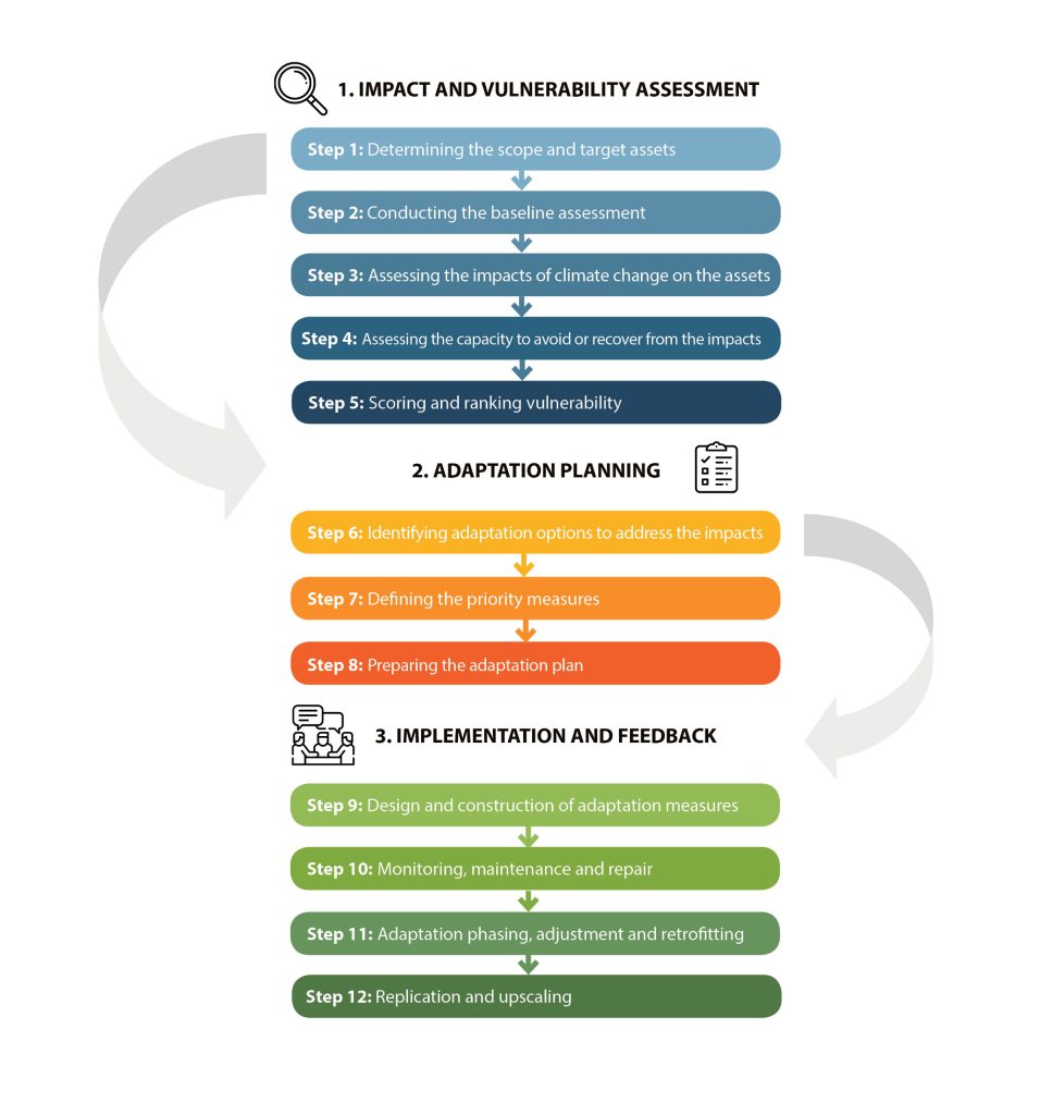
Phase 1 of the CAM (Figure 2) – the impact and vulnerability assessment – has been adapted and applied for the project’s risk assessment.
Figure 2: Steps for performing the climate change impact and vulnerability assessment, adaptation planning and implementation
The CAM process has been applied as follows for the risk assessment of Battambang municipality:
Step 1 – Determine the scope and target assets. The scope of the risk assessment in terms of hazards and threats, geographical area and assets have been defined through a series of consultations with national and city-level stakeholders. The risk assessment primarily focuses on riverine (fluvial) and rainfall-induced (pluvial) flood, riverbank erosion and drought, and the following assets in Battambang municipality: people, transport network, built-up area, and schools and health facilities.
Step 2 – Conduct a baseline assessment. An extensive socio-economic baseline assessment for Battambang municipality has been conducted based on a review of official records and available literature, and information gathered from multi-stakeholder consultations.
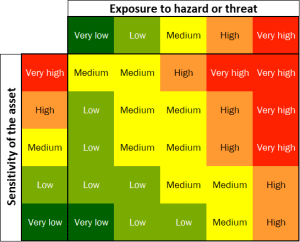
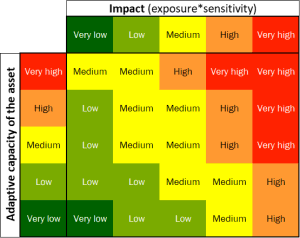
Step 3 to 5 – Assessing impact, capacity and vulnerability. Data derived from available models, census and participatory mapping has been used to determine the exposure, sensitivity and adaptive capacity of the selected assets. Each of these aspects of impact and vulnerability was reclassified into five classes (very low to very high) using a quintile analysis. To score impact and vulnerability, the following CAM matrices have been applied (Figure 3):
Figure 3: Matrices for scoring impact and vulnerability
 |
 |
The flood model used for the risk assessment was provided by the NGO People In Need (PIN) Cambodia, which performed pluvial flood modelling as part of the project ‘Strengthening Climate Information and Early Warning Systems in Cambodia to Support Climate Resilient Development and Adaptation to Climate Change’, implemented from August 2020 to January 2022 and funded by the Cambodia Climate Change Alliance (CCCA).[1] The data collection process consisted of four main activities: i) identification of benchmark; ii) road and topographic survey; iii) aerial survey of 3600 ha and cross-section of the Sangker river; and iv) historical flood level survey. The data was used to develop an urban elevation profile, digital elevation model, digital surface model and digital terrain model. HECRAS software was used for producing the 2D flood model.
[1] PIN, NCDM. 2021. Flood Mitigation Recommendations Report. People in Need and the National Committee for Disaster Management, Phnom Penh, Cambodia.


