| |
||||
| Suburban and urban | Streets | Medium-cost | Pluvial/fluvial flooding | |
| DESCRIPTION | |
| Measures
|
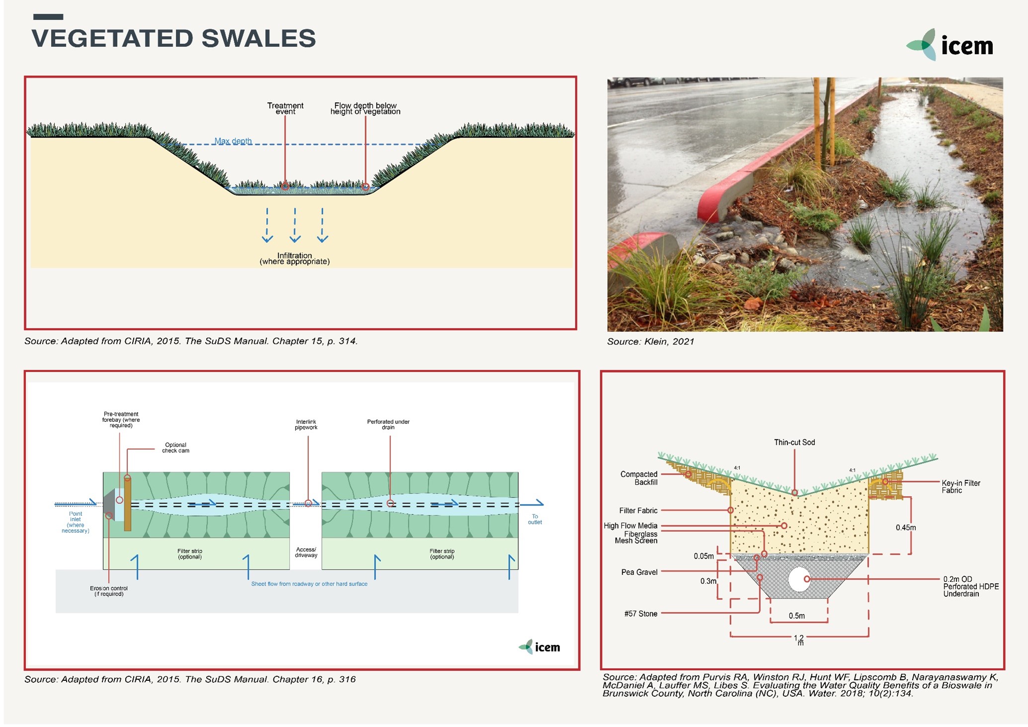
Vegetated swales are wide, shallow channels that provide primary treatment of stormwater run-off while conveying it along the surface. They often have a trapezoidal cross-section and are usually vegetated with turf, grasses or sedges and the stormwater treatment is achieved through filtering and deposition of sediments. The vegetation promotes uniform flow and slows the water velocity to encourage the settlement of sediments and also captures litter and organic matter. When selecting species for planting, the height and density will influence the roughness of the swale and therefore the conveyance capacity and treatment performance.
Swales can be used to: ● Partially manage the first 2.5 cm of rainfall design with no underdrain; ● Manage the first 2.5 cm of rainfall on-site using an infiltration sump design with an underdrain and an infiltration sump; ● Reduce pollutant loads to meet water-quality targets. |
| Location | Vegetated swales are generally suitable for sitting beside paths, roads, and in parks but vehicle access, maintenance safety and water conveyance objectives must be considered during design. Some protection may be required from vehicle damage is considered to be a risk. Whilst swales require additional land in comparison to piped drainage systems, they may also be used as a boundary-defining feature, and be part of the landscape design. They can be integrated into open spaces and public park settings but they do take up some space. When carefully designed, swales can create an interesting landscape. |
| Design options and performance | Vegetated swales are normally located at the upstream end of drainage systems, so they help protect the water quality and hydrology of the receiving waterway. Swales do not permanently retain water and on flatter sites, they may include subsurface drainage. They are not suited to sites with steep slopes (>4%) or large flat areas. Vegetated swales have limited effectiveness in removing fine sediment, nutrient, and heavy metal removal due to their generally short detention times during large storm events. When designing vegetated swales care must be taken to ensure that excessive stormwater flows, slope, and other factors do not combine to produce erosive flows, which could exceed swale carrying capabilities. The use of check dams can enhance swale performance in such situations.
|
| Feasibility criteria
|
Available space: Grass swales can be incorporated into linear development applications (e.g., roadways) by utilizing the footprint typically required for an open-section drainage system. The footprint required will likely be greater than that at a typical conveyance channel because of the limitations on velocity and depth of flow. However, the benefit of the runoff reduction may reduce the footprint for stormwater management elsewhere on the development Site-topography.
Setback: Grass swales should be set back at least 3 m downgradient from building foundations. Similarly, setbacks from septic tank fields and private wells are typically 4-6 m. Site Topography: Grass swales must be constructed at relatively flat grades, so they are most effective on sites with mild to moderate post-construction grades (less than 5%). Pre-treatment: Several pre-treatment measures are feasible, depending on the type of grass swale practice and whether it receives sheet flow or concentrated flow. For pre-treatment structures at the edge of pavement (e.g., grass filter strips, gravel diaphragms, flow splitters), there must be a 5-10 cm drop from the edge of the pavement to the top of the grass or stone in the pre-treatment structure. This is to prevent the accumulation of debris and subsequent clogging at the point where runoff is designed to enter the pre-treatment structure. Technical design: The vegetation can vary from mown turf to sedges but treatment performance is best in systems with dense vertical plantings. The species, height and density of plants specified will influence the roughness of the swale and hence the conveyance capacity and treatment performance. Mown turf will provide a relatively high conveyance capacity compared with sedges, but sedges will provide a greater level of stormwater treatment through increased contact with stormwater flows. Careful consideration needs to be given to the longitudinal grade of the swale and flow velocities since steep grades will result in higher velocities and scour. Relatively flat longitudinal grades can result in the swale invert becoming wet and boggy unless subsurface drainage is provided. Vegetated swales work most efficiently with incoming flows distributed evenly along the length of the swale from the edge of the catchment. Concentrated flows at a single-entry point can damage vegetation and cause erosion. Grass swales should be designed with a bottom width of 0.5–2.0 m, although narrower or wider swales may be used, subject to suitable assessment. Longitudinal slopes should be constrained from 0.5 to 6%. Grass species with a soil-binding root structure and dense cover should be favored along the bottom of the swale to increase infiltration, stabilize soils, and retain and filter pollutants and suspended solids retention. Soil media: n/a Soil slope: less than 4% Surface cover: Vegetation should be selected based on local climate and rainfall regime, be of sufficient density, and be maintained at a height above the treatment flow level to maximize filtration. Materials: Equipment for excavation, drainage pipework if provided and plants. |
| Operation and
maintenance |
A high initial level of maintenance is required during the establishment of the vegetation, and then ongoing periodic monitoring for replacing vegetation cover, and infrequent mowing and litter removal. Regular maintenance will ensure continuous operation to design performance standards, and all designers should provide detailed specifications and frequencies for the required maintenance activities along with likely machinery requirements and typical annual costs. |
| Cost and benefits | Vegetated swales provide a low-cost stormwater conveyance system since the cost is generally lower than the cost of an equivalent piped system. They also provide primary treatment through the settlement of course sediments and capture significant amounts of litter and organic matter. |
| Design solution | Vegetated swales carry stormwater and, on mild slopes, can be used instead of pipes but in addition to the conveyance they also remove coarse and medium sediment. They are commonly combined with buffer strips so that overland flow is slowly conveyed downstream. In contrast to hydraulically efficient pipe drainage systems, the stormwater in swales flows at a slower rate, which in the case of imperviousness catchments, reduces the peak flow rate. As the stormwater passes along the swales the vegetation facilitates the settlement of pollutants and flow retention whilst spreading the flow and slowing velocities which aids the sediment deposition process. While swales alone rarely provide sufficient treatment to meet objectives for all pollutants, they can provide an important pre-treatment function for other Water Sensitive Urban Design (WSUD) measures. |
| Environmental performance | Vegetated swales should be designed so that they integrate well with the characteristic landscape of the surrounding area. Appropriate native vegetation should be selected so that they enhance the aesthetic value of a site and discreetly blend in with landscaping features, especially when adjacent to roads. |
| Sources | ● AECOM/Townsville City Council, 2011. WSUD Technical Design Guidelines for the Coastal Dry Tropics: Chapter 2, Swales (incorporating buffer strips).
● CIRIA, 2015. The SuDS Manual 2015. Chapter 17, Swales. ● Melbourne Water, 2005. WSUD Engineering Procedures: Stormwater. ● Pennsylvania Stormwater, 2006. Best Practice Manual – Chapter 6. ● Susdrain, not dated. Delivering SuDS – Swales and Conveyance Channels. |
Originally developed under the ADB ‘TA-9417 VIE: Secondary Green Cities Development Project – Output 2: Demonstrated sustainable and resilient development in Hue, Ha Giang and Vinh Yen’. Adapted for the UN-CTCN project ‘Climate risk assessment for subnational adaptation and establishment of a local climate information system for climate change adaptation (LISA) in Cambodia’.