| Suburban | River | Low-cost | Riverbank erosion | |
| DESCRIPTION | |
| Measure | Erosion of the bank surface caused by the impact of raindrops (splash erosion) can be a major problem on banks fully or partially denuded of vegetation. The vegetation, by blocking the rain, reduces its impact and prevents splash erosion, while the root systems reinforce the soil and increase the infiltration rate. By decreasing the volume of runoff and runoff velocity, vegetation also limits the capacity of the runoff to detach soil particles (which leads to sheet, rill and gulley erosion). In addition, the roots absorb water from the soil and release it to the atmosphere through evapotranspiration thus helping to create negative pore water conditions in the soil and increase the stability of the bank. Vegetation consists mainly of grasses, herbaceous plants and shrubs, but it takes time to establish, so for stabilizing banks, planting is frequently used with other hybrid or grey measures. |
| Location | Planting of vegetation along riverbanks should usually be the first option to protect a riverbank from the effects of erosion since as well as binding the soil together it buffers wave action and greatly benefits the local landscape while increasing biodiversity at a minimal cost. It should therefore be considered in all situations where the bank is not already eroded to an extent where more robust measures are needed and it is usually an option to combine with other hybrid measures. |
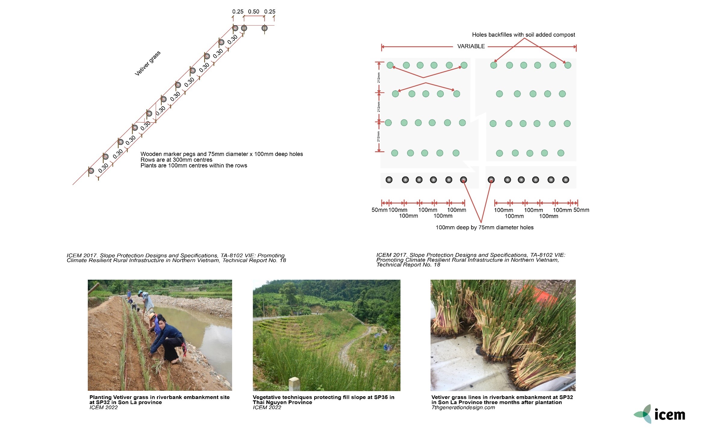
| Design options and performance | Under ADB/TA8102-VIE various detailed manuals for the design and implementation of different bioengineering measures including grass planting have been developed including planting from seeds using bamboo mesh to stabilize the soil. The manuals also include green/grey measures where vegetation planting is combined with grey measures including masonry frameworks and gabions implanted with grass or other plants. |
| Feasibility criteria
|
Should not be used on the lower part of the bank slope if subject to high-velocity river flows.
● Technical design: Issues to consider before planting are: soil suitability and preparation, sowing times and resistance to erosion while plants are establishing, ● Soil media: The in-situ soil characteristics should be taken into consideration when selecting the plant species to be planted ● Soil slope: Planting can be used to strengthen any bank slope providing that the bank to be planted is stable and not actively eroding. ● Surface cover: Some form of matting may be required to support the soil if it is loose and at risk of erosion ● Materials: Digging implements, plants and matting if used. |
| Floodplain
widening |
By maintaining some of the natural floodplains, setback banks allow for increased conveyance. Setbacks are earthen embankments that are located at a distance from a river channel in such a way as to allow the river to collect the water more naturally and occupy some or all of its natural floodplain during high water events.
Alternatively, a riparian buffer can be adopted in the floodplain area. A riparian strip is a strip of hydric soil with facultative vegetation along the banks of a river or stream offering niche ecotone services. Riparian buffers are a simple, inexpensive way to protect and improve water quality through local plant communities. Buffer strips structurally stabilize banks and shorelines to prevent erosion and slumping. Between 50 and 85% of stormwater pollutant loads can be filtered within 30 to 100 meters of vegetated buffers. Trees and shrubs provide shade to maintain the consistent water temperature necessary for nutrient exchange and the survival of some aquatic life. Buffer width is based on the surrounding context, soil type, size and slope of watershed area, and vegetative cover. Setback levees, like more traditional levees, require regular maintenance. |
| Operation and maintenance | The young plants need to be checked regularly to ensure that they are developing properly but once established the bank vegetation only needs attention if its growth is infringing on the river channel or if invaded by invasive species. |
| Cost and benefits | Planting vegetation along riverbanks is the least costly and most natural measure for protecting the bank and will improve the riparian environment and providn improved habitat for wildlife. |
| Design solution | Planting slopes with vegetation to resist erosion is a simple and low-cost solution and also a long-standing practice that provides robust protection and shallow reinforcement of the surface soil. It is the best and quickest way to create a surface vegetation cover on a bare slope and can effectively cover almost all soil slopes up to 2V:1H. It is however dependent on the type of plant used, root depth and leaf ratio so it requires careful selection of species. Regular maintenance is needed during the early stages until the vegetation becomes fully established and this may be up to 3 years in some cases particularly where groundwater is low or absent. |
| Environmental performance | Soil erosion, if unchecked will put the survival of any vegetation system at risk, leading to the deterioration or loss of the productive capacity of the underlying soils. Providing vegetation cover is a nature-based solution and one of the most effective tools to counteract erosion because the plant roots hold the soil in place and prevent it from being blown or washed away. It restores the slope or riverbank’s capability for resisting storm damage and provides wildlife habitat. |
| Sources | ● ICEM, 2017. Slope Protection Designs and Specifications, TA-8102 VIE: Promoting Climate Resilient Rural Infrastructure in Northern Vietnam, Technical Report No. 18.
● Mississippi Watershed Management Organization. 2017. A Guide to Bank Restoration Options for Large River Systems: Part II Bioengineering Installation Manual. |
Download PDF
Originally developed under the ADB ‘TA-9417 VIE: Secondary Green Cities Development Project – Output 2: Demonstrated sustainable and resilient development in Hue, Ha Giang and Vinh Yen’. Adapted for the UN-CTCN project ‘Climate risk assessment for subnational adaptation and establishment of a local climate information system for climate change adaptation (LISA) in Cambodia’.